


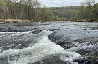
Cover photo: Along the Cacapon River in West Virginia, low-lying rock ledges lead to a quickening of the pace. None of the rapids are classified higher than Class II, making for a relatively stress-free paddle. (Jeremy Cox)
It has been some days, as of this writing, since my canoe trip down a 9-mile segment of West Virginia’s Cacapon River, but one scene continues to play on a loop in my memory.
It goes like this: The tip of our two-person canoe approaches a ledge — basically a miniature waterfall. Seated in the front, I watch as the bow dips forward a couple feet, yanking us and the rest of the vessel downward. My stomach recoils. The water froths. Rocks scrape the hull from every direction.
My inner dialogue takes over: “Did I lean too far? Is the seat slipping out from under me?” I dig the outer sides of my legs into the canoe’s metal rim. No time for breath. Only hanging on.

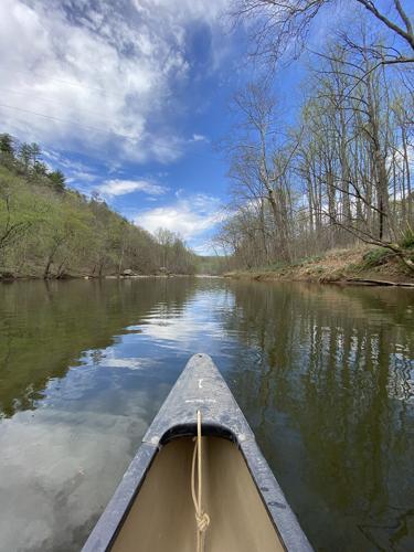
The prow of a canoe points downstream on the Cacapon River in West Virginia to gentle rapids in the distance, where the river's rocky banks close in.
Then, stability returns. What seemed impossible a few seconds ago — making it past this ledge dry and upright — has turned into exuberant reality. A thrill blooms, rises to my lips and escapes into the air as a falsetto “Wooooooooo!”
We careened down so many ledges that April day, I lost track of the number. But each was just as exciting as the last.
Before I sound too self-congratulatory, it should be noted: Nothing along this stretch would qualify as anything more than Class I rapids, the gentlest category of moving water. And the rapids were interspersed by much longer, peaceful sections of walking-pace currents.
The result: a memorable ride through stunning sandstone gorges and leafy landscapes that even novice whitewater paddlers (like me) can enjoy.
As rivers go, the Cacapon (pronounced “kuh-KAY-pun”) is a strange animal. To begin with, the river flows from south to north, emptying into the Potomac River about 80 miles west of Washington DC. So, when you head upstream, you’re moving south.
And, in a way, it’s two rivers in one. There is a 31-mile upstream segment known as the Lost River. This is because it disappears beneath a rocky ridge when water levels are low. But even when it’s not visible at the surface, the river continues underground for more than a mile between the towns of Baker and Wardensville.
Once it reemerges, it becomes known as the Cacapon, derived from a Native American word for “medicinal waters.”
The combined 112-mile course drains 680 square miles.
Despite relentless development pressure from the DC metropolitan area, about 85% of the Lost/Cacapon River watershed remains forested. This natural buffer helps to filter stormwater flowing off surrounding farms, and the Cacapon’s waters are clearer for it.

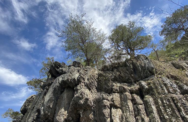
A rock outcrop looms at the edge of the Cacapon River, which flows through valleys and gorges in West Virginia between the Blue Ridge and Allegheny mountains.
On a sun-bedazzled Friday morning, I joined a dozen paddlers for a planned group outing down a winding section of the Cacapon. We put in on the east side of the WV Route 127 bridge and wended our way downstream to a takeout at Cacapon Crossings. Both access sites are public and maintained by the state Division of Natural Resources.
The area generally corresponds to the rustic middle portion of the Cacapon. Here, no roads parallel the river. Except for a gated community straddling the final mile, there are only a smattering of home sites. Much of the land is either too rugged for development or under some form of protection.
Our flotilla consisted of several local environmental movers and shakers. Among them: Emily Warner, executive director of the Cacapon & Lost Rivers Land Trust; Glenn Archer, vice president of the Friends of the Cacapon River; Ryan Cooper, the region’s conservation planner for Trout Unlimited; and Will Evans, an eco-logical restoration coordinator with the West Virginia Nature Conservancy.
I had lugged my own kayak from home, a four-hour drive away on the Eastern Shore of the Chesapeake Bay. But when Archer offered up the front seat of his canoe, I readily accepted.
I had been uncertain about how my experience on flat water would translate to a more kinetic environment. I’m accustomed to tides and wind. But rocks and rapids are not often found on the Eastern Shore.

Court Ogilvie, left, and Glenn Archer set off on West Virginia's Cacapon River after launching at the Route 127 bridge boat ramp.
It turned out that Archer’s knowledge of these types of waters and his proficiency with an oar more than compensated for my shortfalls. He whiled away his summers as a youth on his grandparents’ farm along the Cacapon a little way upstream from where we were paddling. With their children now grown, he and his wife recently returned to live on the property most of the time.
Archer’s expertise was on display almost immediately. Within a few hundred yards of launching, we arrived at an outcropping of submerged rocks. While others in our party scrambled out of their kayaks or canoes to drag them to deeper water, Archer stayed seated. Using his oar like a pole, he freed us with a few smart thrusts of his blade into the river’s hard bottom.
Much depends on precipitation. If there isn’t enough, the Cacapon will be too shallow to float even a kayak. The general rule is that the gage at the town of Capon Bridge must register at least 2 feet in depth to make paddling possible. That’s usually the case in the spring and fall but rarely so in winter and summer.
If we had scheduled our trip a few days later, it’s unlikely we would have been able to pull it off. It hadn’t rained the previous two weeks. Water levels were low and dropping.
No matter how often he paddles the Cacapon, Archer said, he never encounters the same river twice. Rainfall, or the lack thereof, alters the depth, which in turn dictates the speed of the current, the height of the ledges and how much the rocks come into play.
Court Ogilvie, a solo paddler on this trip, put it this way: “I love it when it pours. It opens up so many opportunities. It’s like snow to a skier.”

Canoers on the Cacapon River in West Virginia float past a patch of gentle rapids.
The one constant with the Cacapon, everyone seemed to agree, is the clarity of the water. I had no trouble seeing the bottom. This is mostly a function of the watershed’s relative lack of rooftops, roads and other types of drainage-blocking land cover.
“See that chute there?” Archer called out from the canoe’s rear. I had no idea what that meant. Before I could ask, he was giving orders: “Hard paddle! Hard right!”
A “chute,” he would explain to me once we had cleared the rapids, is a triangle-shaped wedge of free-flowing water that signals where gaps can be found between underwater rocks. You want to aim for those to avoid getting hung up on the rocks or catching an infelicitous current.
There were times when we would approach a ledge, and then, finding the chute too constricted or the downstream rocks too menacing, find ourselves paddling perpendicular to it until we could locate a more suitable entry point.
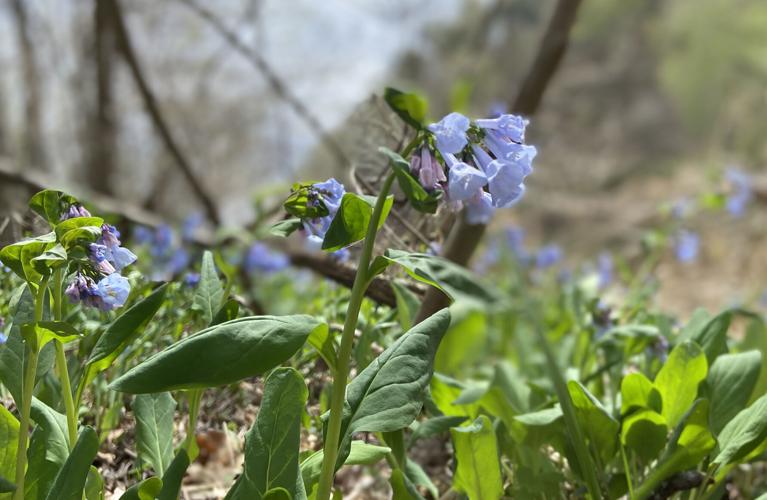
The scenery was a delight. For much of their length, the banks were coated with lavender-blue flowers. These native plants, Virginia bluebells, don’t grow much more than a foot or two high, but they still put on quite a show. The hills were also bursting with dabs of pink from the blooming Eastern redbud trees.

Virginia bluebells are a ubiquitous springtime sight along the edge of the Cacapon River in West Virginia.
At one point, Archer and I rested at the base of a bluff while the others caught up to us. Suddenly, he pointed to a skinny slick of brown fur stirring at the surface of the water barely 10 feet in front of us. It swam ashore, betraying its identity as a baby otter. It was carrying a small fish in its mouth.
The two of us just sat in awe. For the rest of the journey, we described the encounter over and over again to each fresh pair of ears.
You would have thought that we had timed our get-together for the spring bud break. When we first sank our oars into the water in the morning, the sycamores, oaks, tulip poplars and other deciduous trees still sported the bare branches of winter. Gently baked in the gathering warmth, the leaves began to emerge throughout the day. By late afternoon, all seemed green and lush.
That’s probably not entirely true. But in the afterglow of a long, spirit-cleansing paddle, memories are all that matter.
(0) comments
Welcome to the discussion.
Log In
We aim to provide a forum for fair and open dialogue.
Please use language that is accurate and respectful.
Comments may not include:
* Insults, verbal attacks or degrading statements
* Explicit or vulgar language
* Information that violates a person's right to privacy
* Advertising or solicitations
* Misrepresentation of your identity or affiliation
* Incorrect, fraudulent or misleading content
* Spam or comments that do not pertain to the posted article
We reserve the right to edit or decline comments that do follow these guidelines.